

Garmin 010-02256-00 eTrex 22x, Rugged Handheld GPS Navigator, Black/Navy
Original price was: $199.99.$180.00Current price is: $180.00.


Price: $199.99 - $180.00
(as of Nov 03, 2025 16:43:03 UTC – Details)
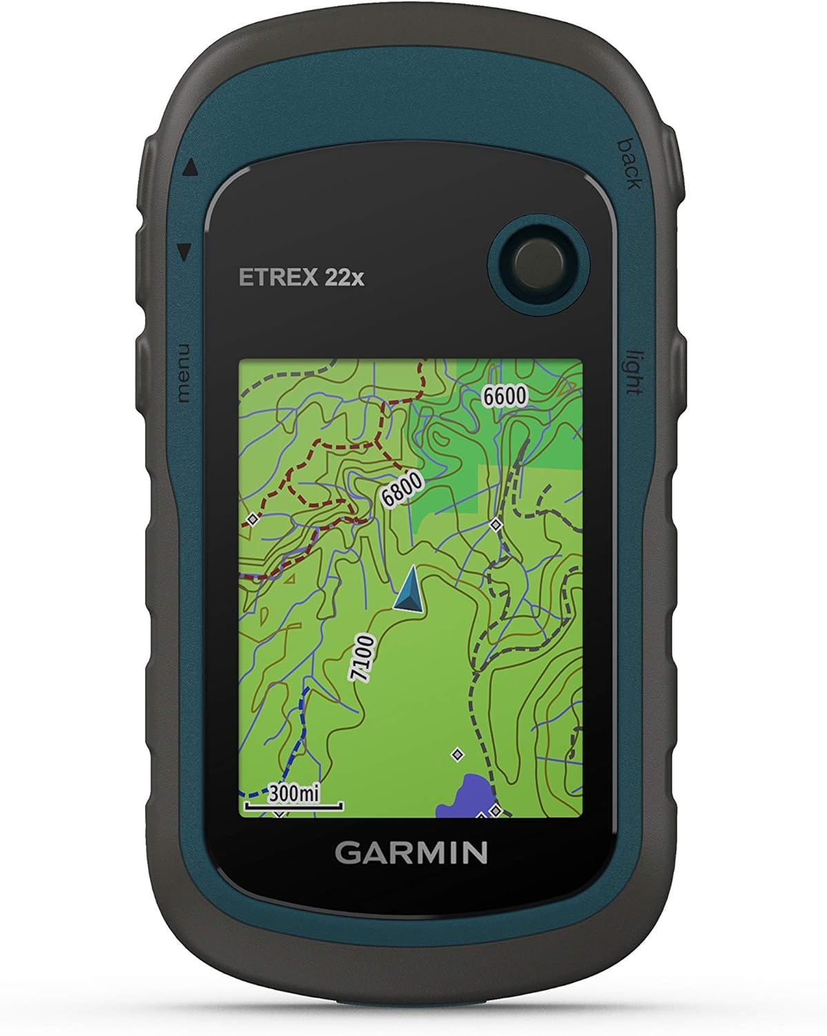
Explore with confidence with Terex 22x, a rugged GPS handheld with a 2.2” sunlight-readable color display. It comes preloaded with Topo Active maps featuring routable roads and trails to explore when cycling and hiking. Add even more mapping via the micro card slot and 8 GB of internal memory. With dual-satellite support (GPS and GLONASS), it tracks in more challenging environments than GPS alone.
Explore confidently with the reliable handheld GPS
2.2” sunlight-readable color display with 240 x 320 display pixels for improved readability
Preloaded with Topo Active maps with routable roads and trails for cycling and hiking
Support for GPS and GLONASS satellite systems allows for tracking in more challenging environments than GPS alone
8 GB of internal memory for map downloads plus a micro SD card slot
Battery life: up to 25 hours in GPS mode with 2 AA batteries
Customers say
Customers find the GPS unit to be a fantastic navigation instrument that is accurate and easy to read and learn. However, the functionality receives mixed feedback, with some saying it works well while others report it being unusable. The screen size is criticized for being really small, and opinions on value for money are divided between those who find it good for the price and those who consider it a waste of money. Customers disagree on the device’s usefulness, with some finding it good for hiking while others report it being useless for wilderness navigation.
11 reviews for Garmin 010-02256-00 eTrex 22x, Rugged Handheld GPS Navigator, Black/Navy
Add a review
Related Products


Original price was: $199.99.$180.00Current price is: $180.00.
Carl –
Small good gps
It’s a Garmin so good quality and customer service. You need to register the device on Garmin’s website and download their free map. To do this it requires you to buy a little SD card and put it in the device. It took close to four hours for the map to download, ugg! It is easy to use, the directions are clear. It has a little toggle stick to move through and select what you want it set to. If you are buying sight unseen, be prepared for how small the screen is, it is small. I have had it out in the wilderness, and it is a handy little gps.
Russell Palmer –
Worth the money
Priced right and works great!
New Hampshire Hiker –
Reliable basic GPS
4 stars because 5 would be perfect. NO NAVIGATION INSTRUMENT is 100% perfect 100% of the time.I have used this for a couple weeks walking and driving around town and hiking in The White Mountain National Forest. It DOES A GOOD JOB FOR THE MONEY!NEED TO KNOW. My unit would not work until updates were installed. The Open Source map is a GLOBAL (the entire planet) shaded relief map. That is a colossal amount of data. Plan on adding a micro SD card for extra memory, connecting to a computer and allowing LOTS of time for updates before using. After updating you may choose only the map regions you need to save memory. I like having the whole planet! Also, there is NO “lock safety” for the toggle and buttons. Be careful not to have them pressed while carrying the unit in a pouch or case.A little about me. I have been hiking/camping for over 50 years and never been “lost” for more than a short time (99.9% who say they never get disoriented occasionally either never goes out or lies). I could always get back to a known point in a reasonable time with map/compass, with both or only one (paper maps & magnetic compasses can be off too!). I do know how to get around in the woods. I do NOT backpack without paper map & magnetic compass.I have been using a handheld GPS for several years. They are good tools when properly used (always with paper map & magnetic compass). This Etrex 22x replaces my Garmin Oregon that was dropped & lost in a National Forest (Lesson learned, keep it tethered).In some ways I like the Etrex22x better.It has a nonslip side and fits my hand nicely. It is one hand usable (I think light weight gloves will be ok with it). The included Open Source map is more than adequate for basic navigation. This map is updated by users and in some places provides info only a user would be able to contribute. This map has some points paper maps do not have. You can add micro SD cards for specific maps. It’s helpful to compare information on several maps while backpacking.Etrex 22x has all the basic features/functions needed for general navigation.There is, of course, a learning curve. Garmin support is VERY HELPFUL. Be sure to use their expertise and learn the device BEFORE you go out.Some product info is confusing because the manual is for two GPS units (and, of course, some YouTubers are not correct).Etrex22x does NOT have a 3 axis compass or barometric altimeter. The compass only knows direction while moving (remember your magnetic compass!). The altimeter DOES know elevation from the satellite beacons. I have a barometric altimeter and have compared it to the etrex22x. I find the 22x more reliable. In TRACK MANAGER and ROUTE PLANNER you will find an elevation plot.Etrex 22x CAN BE used for automotive navigation. It WILL relocate route on roadways. It can also plan routes for bicycle and pedestrian. You must select mode of travel.Etrex 22x Open Source map DOES have some boundaries for state and federal lands. These boundaries are not as detailed as what is provided with micro SD cards, but do give the general area. Open Source maps are updated as new info becomes available. Check for updates every once-in-awhile.Overall, I am confident that the etrex 22x will track my hike and give me the info I need to navigate The White Mountain National Forest and Wilderness areas (some impressively varied terrain!), on and off trails (again, along with a magnetic compass and paper map). This replaces a much more expensive GPS unit that had a map specific card installed. It was a tough act to follow. It does well. For the money, I am impressed.
Christine –
Good budget friendly GPS
My 13 year old son was going on a 10 mile hike with 3 of his friends in a place with no cell phone service, we got this as a primary GPS for him to use to make sure they didnt get lost as the trails are not clearly marked. We downloaded the GPX file for the trail and uploaded to the unit, he was able to follow it and mark way points along the trail. He was also using Gia Gps with the same GPX file on his phone when we got home we compared the data between the 2 devices and the data was very similar. The screen is small and the user interface is a bit dated but its basic and it works. For short hikes this is a good unit, if you need a backup for longer hikes or planning on being out for a few days this is a great secondary GPS.
Jon sanderson –
Harmon etex 22
Nice small gps unit easy to use.
Daniel K. –
User Friendly?
I really wanted to like this GPS. From reading some of the Reviews many people found it worked great for them. That wasn’t my experience. The ETREX 22X is trimmed in a dark blue with the Function buttons labeled in black. I found the function buttons hard to read. For me, the screen is unreadable in daylight. I couldn’t get the Topo maps to load in the Tracks function. I couldn’t get the Tracks function map to read anything but about 20′ on a black background, and I couldn’t get a Zoom In & Out to work. So, no perspective on where you are relative to starting point or map landmarks. Also, forget about backtracking. I downloaded the Online Manual hoping that would help. Some of the Commands & Functions in the Manual are not available on the GPS. So, the manual wasn’t really any help.I think if Garmin wants to hold onto their customer base, they should think about putting out some Tutorial Videos for each of their GPS’s, that individually cover topics like; Tracks, Waypoints, Routes, Maps, and maybe an overall video that shows some of the highlights and how to navigate their systems on a granular level to offer some customer satisfaction after the sale.The more I used the GPS, the more confused and frustrated I got, and I’ve owned and used a number of Lorans & GPSs over the years, and this was by far the most difficult to operate. I was able to return it within the 30-day window and am very happy I did!
Glen McKinnon –
Bush walking
若森 孝 –
日本語の説明書や本体の表示が全く理解出来なく、返信して何か騙されてお金を取られた気持ちですね。凄く残念です。
josephstalin –
This german device is very helpful for my profession. Because i am a land surveyor so so much easier to survey the land
Blackeagle –
Perfect! Exactly what we needed. Glad we purchased this unit and not a Chinese knock-off. This one is more expensive, but this is a well spent money. Most of the cost goes into a well honed software.The software is good. It performs as expected. At least for what we need. i.e: waypoints, tracks and area calculation.We use it as a track recording device and then we import the recordings and process them on a PC. We also prepare tracks on the PC, import them in the device and march them once in the field. The ability to see our current position relative to a programmed track is nice. The screen is a bit small for my aging eyes. This is not a product issue. We understand that something to be used during hiking must be small and light. Bigger is not better. Beside that a bigger screen would be very taxing on the batteries.We used the device for a few hours and the two AA alkaline batteries are still full.The color LCD screen is transflectif giving an excellent readability in full sun (which requires less back light which in turn requires less energy, hence more autonomy to the batteries).The manufacturer states an accuracy of 4 meters. When we stand still for an extended period of time, we can see our position randomly jumping around a point. Given enough time, it is possible to assume that the average position is quite accurate. For our needs, 4 meters is enough.Overall it is an excellent product. We did not test all functions.
Nestor Segoviano –
Excelente producto anteriormente en la oficina usaba estos gps, compacto y precisos al momento de realizar marcaciones o waypoints y trazado de mapas, super útiles para el trabajo de campo. 100 x 100 recomendable el producto así como el vendedor.